Map - Tauragė

Tauragė
Tauragė (see other names) is an industrial city in Lithuania, and the capital of Tauragė County. In 2020, its population was 21,520. Tauragė is situated on the Jūra River, close to the border with the Kaliningrad Oblast, and not far from the Baltic Sea coast.

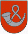
Although first mentioned in 1507, Tauragė received its city charter only in 1924 and its coat of arms (a silver hunting horn in a red field) in 1997. Notable buildings in the city include the castle (19th c. Russian Empire Customs) (currently housing Tauragė Region Museum, Tourism Information Centre), 19th c. Post office, beautiful buildings from the 20th c. inter-war period, several churches: the Lutheran (built in 1843), the Catholic (1904) and Orthodox (1933). Lithuanian, Swedish and Danish factories operate in the city. Nowadays Tauragė is famous for its car markets and adventure parks.

In Lithuanian, Tauragė is a conjunction of two words: tauras which means "aurochs", and ragas which means "horn", hence the city's coat of arms. The city is known as Tauragie in Samogitian, as Tauroggen in German, Taurogi in Polish, Tovrig (טאווריג) in Yiddish, and Taurage (Таураге; historically Tauroggen [Таурогген] or Taurogi [Тауроги]) in Russian.

 
Map - Tauragė
Map
Google Earth - Map - Tauragė
Google Earth
Openstreetmap - Map - Tauragė
Openstreetmap
Map - Tauragė - Esri.WorldImagery
Esri.WorldImagery
Map - Tauragė - Esri.WorldStreetMap
Esri.WorldStreetMap
Map - Tauragė - OpenStreetMap.Mapnik
OpenStreetMap.Mapnik
Map - Tauragė - OpenStreetMap.HOT
OpenStreetMap.HOT
Map - Tauragė - OpenTopoMap
OpenTopoMap
Map - Tauragė - CartoDB.Positron
CartoDB.Positron
Map - Tauragė - CartoDB.Voyager
CartoDB.Voyager
Map - Tauragė - OpenMapSurfer.Roads
OpenMapSurfer.Roads
Map - Tauragė - Esri.WorldTopoMap
Esri.WorldTopoMap
Map - Tauragė - Stamen.TonerLite
Stamen.TonerLite
Country - Lithuanian_Soviet_Socialist_Republic_(1918–1919)
Flag of Lithuania
The Lithuanian Soviet Socialist Republic (LSSR) was a short-lived Soviet Puppet state during early Interwar period. It was declared on 16 December 1918 by a provisional revolutionary government led by Vincas Mickevičius-Kapsukas. It ceased to exist on 27 February 1919, when it was merged with the Socialist Soviet Republic of Byelorussia to form the Lithuanian–Byelorussian Soviet Socialist Republic (Litbel). While efforts were made to represent the LSSR as a product of a socialist revolution supported by local residents, it was largely a Moscow-orchestrated entity created to justify the Lithuanian–Soviet War. As a Soviet historian described it as: "The fact that the Government of Soviet Russia recognized a young Soviet Lithuanian Republic unmasked the lie of the USA and British imperialists that Soviet Russia allegedly sought rapacious aims with regard to the Baltic countries." Lithuanians generally did not support Soviet causes and rallied for their own national state, declared independent on 16 February 1918 by the Council of Lithuania.

Germany had lost World War I and signed the Compiègne Armistice on 11 November 1918. Its military forces then started retreating from the former Ober Ost territories. Two days later, the government of the Soviet Russia renounced the Treaty of Brest-Litovsk, which had assured Lithuania's independence. Soviet forces then launched a westward offensive against Estonia, Latvia, Lithuania, Poland and Ukraine in an effort to spread the global proletarian revolution and replace national independence movements with Soviet republics. Their forces followed retreating German troops and reached Lithuania by the end of December 1918.
Currency / Language  
ISO Currency Symbol Significant figures
EUR Euro € 2
Neighbourhood - Country  
  •  Belarus 
  •  Latvia 
  •  Poland 
  •  Russia